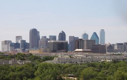
UNIVERSITY PARK, TEXAS. University Park is
on U.S. Highway 75, and Loop 12 five
miles
north of downtown Dallas in central
Dallas
County, bordered by the city of Dallas
on
the north and east and Highland Park
to the
south. Its name originated because
of its
location adjacent to Southern Methodist
University.
SMU officially opened in 1915, and
homes
were built around the campus to house
teachers
and staff of the university. Water
for the
campus came from artesian wells and
an overhead
storage tank, and sewage lines were
connected
to Dallas's lines in Oak Lawn. Homes
in the
area were joined to the university
water
and sewer lines, and homeowners paid
the
university for these services. By 1924,
with
more than 380 homes in the area, the
university
could no longer afford to supply water
and
sewer lines to residential areas.
The cities of Dallas and Highland Park
refused
to annex the University Park area because
of the financial burden of laying new
sewer
lines and supplying garbage removal
and police
and fire protection. Therefore, in
1924 the
city of University Park was incorporated
with a population of 1,200. The first
city
government consisted of a mayor and
five
aldermen, but on April 6, 1926, residents
voted to adopt a commission form of
city
government, which the city still retained
in 1992. On August 16, 1924, a $150,000
bond
election was held to set up fire protection
and to finance water and street improvements.
The town organized its own garbage-disposal
system in 1925. Snider Plaza, a popular
shopping
center, opened in 1927, although it
remained
largely undeveloped throughout the
Great
Depression. The population of University
Park grew rapidly, mirroring the growth
of
Southern Methodist University and the
nearby
cities of Dallas and Highland Park.
By 1945 University Park had an estimated
population of 18,000 and 120 businesses.
In that year the city of Dallas attempted
to annex the cities of Highland Park
and
University Park, commonly referred
to as
the Park Cities, but was turned down
by a
narrow margin. After their refusal
of a merger,
Dallas used its home rule powers to
annex
territory adjacent to University Park,
cutting
off all land for expansion. University
Park
still relied on the city of Dallas
for such
services as water and sewage treatment,
but
in 1947 the Park Cities set up their
own
Water Control and Improvement District
to
take over these functions. A water-purification
plant, reservoir, and pressure tank
were
completed in 1950. Because it was surrounded
by Dallas, University Park was prevented
from annexing land for growth as most
communities
in Dallas County did, and its area
remained
3.7 square miles. Few lots were left
vacant
on which to build new homes.
The population rose from 4,200 in 1930
to
14,458 in 1940 and 23,823 in 1950.
Between
1950 and 1990 it fluctuated moderately,
reaching
an estimated 28,500 in 1956. In that
year
University Park had eleven churches
and seven
parks. Its schools formed part of the
Highland
Park school system, an arrangement
still
in effect in 1992. The 1990 population
of
22,259 was primarily white, 3 percent
Hispanic,
and 1 percent black. The university
remained
the largest employer, and businesses
continued
to be primarily university or student
related. |
HIGHLAND PARK, TEXAS. Highland Park, on State
Highway 289 and State Highway 75 four
miles
north of downtown Dallas in central
Dallas
County, is a 2.2-square-mile residential
"island city" surrounded
by Dallas
on the south, east, and west and University
Park on the north. In 1889 the land
was bought
by a group of Philadelphia investors,
the
Philadelphia Place Land Association,
for
an average price of $377 an acre, or
$500,000
total. Henry Exall, acting as agent,
intended
to develop the land along Turtle Creek
as
Philadelphia Place, an area of exclusive
housing modeled after parkland housing
in
Philadelphia. He laid out gravel roads
and
built a dam across Turtle Creek to
form Exall
Lake before the panic of 1893 destroyed
the
Dallas land boom and ended the development.
Exall lost everything except his horse
and
some of the land. He subsequently began
a
breeding farm, Lomo Alto Horse Farm.
During
the 1890s Exall Lake was a favorite
picnic
destination for Dallasites. Bass and
perch
abounded in it, and a steamboat operated
on it. Exall bred horses with his stallion
Electrite until 1906, when John Armstrong
bought the land for a residential development.
Armstrong had been a partner of Thomas
L.
Marsalis in the development of Oak
Cliff
but sold out to open a meatpacking
business.
With the sale of his business he invested
the money in 1,326 acres of the former
Philadelphia
Place land to develop under the name
Highland
Park. Armstrong, along with his sons-in-law
Hugh Prather and Edgar Flippen, gave
Highland
Park its name because of its location
on
high land overlooking downtown Dallas.
The
investors hired Wilbur David Cook,
a landscape
architect of Beverly Hills, California,
to
design the layout. In addition, George
E.
Kessler, who designed Fair Park and
much
of downtown Dallas, was hired to help
in
planning and development. Twenty percent
of the original land was set aside
for parks.
The first 100-acre addition was begun
in
1907 and promoted with the slogan "Beyond
the City's Dust and Smoke." Later
appeared
the slogan "It's Ten Degrees Cooler
in Highland Park." The second
development
in Highland Park, the Lakeside addition,
was developed in 1910.
In 1913 Highland Park asked Dallas
for annexation
but was refused. The 500 residents
therefore
voted to incorporate, on November 29,
1913.
The incorporation officially took place
in
1915, when the population was 1,100;
W. A.
Fraser was the first mayor. Highland
Park
set up its own waterworks, which it
operated
until 1932. In 1915 the third addition
to
Highland Park was built, and two years
later
a fourth. After two years a long annexation
controversy began. The city of Dallas
regretted
its earlier refusal to annex Highland
Park
and began a battle that lasted until
1945,
when Dallas was turned down for the
last
time. The last major land development
in
Highland Park, Highland Park West,
was built
in 1924. In 1931 Highland Park Village,
the
first shopping center of its type in
the
United States, was constructed in Highland
Park.
By 1933 Highland Park had a population
of
8,422 and twelve businesses. Its resident
population was large, but few businesses
and no industry operated in the city.
From
1932 to 1950 Highland Park bought water
from
the city of Dallas, but in 1950 Highland
Park and University Park, the "Park
Cities," began their own waterworks.
In 1949 Highland Park had four elementary
schools, a junior high, and a high
school.
Later the Park Cities combined their
school
districts, as they did their newspapers.
The Park Cities News was established
in 1938
and the Park Cities People in 1981.
In the
late 1950s Highland Park had a population
high of 12,900, before beginning its
slow
decline to its 1990 level of 8,739.
After
its attempt to annex Highland Park
was defeated,
Dallas annexed the land around it.
Highland
Park was forced to grow only by building
houses on the few remaining vacant
lots,
or by tearing down old buildings to
construct
new ones. In the 1989-90 school year
the
Highland Park Independent School District
had four elementary schools, one middle
school,
and one high school for its 4,066 students.
In 1990 Highland Park had strict zoning
ordinances.
Its reputation for quality housing
was enhanced
by the abundance of parks running along
Turtle
Creek and by the Dallas Country Club,
which
is in Highland Park.
|